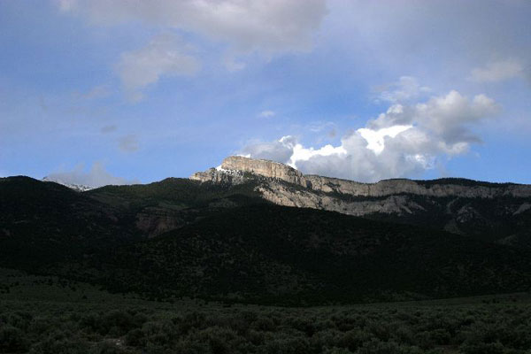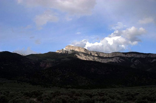
[STEWART BRAND:] Nevada. In 02002 the Long Now board decreed it was time to examine our mountain physically and to contemplate deeply whether it is the right place for a 10,000-year Clock. Accordingly, June 02003 was scheduled for a proper multi-week expedition to Mt. Washington, culminating with a board meeting at the site.
My emotional executive summary is this: I had more fun exploring and living at Mt. Washington than anything I've done in years. Every day was an adventure.
All during the expedition Danny Hillis kept telling variations of his theory of "The 7 Stages of a Mythic Experience" as a way to think about how the mountain and the Clock might fit together. After the trip I asked him to write up the ideas fully. Here they are:
Stewart,
You ask me to write up a short summary of the design issues that I have been thinking about for the experience of visiting the clock. Here it is.
The visit to the clock is intended to be a kind of Hajj, a spiritual journey. As such it needs to have certain elements. One of the design issues for the clock is how to provide these elements. Below is a description of seven of the elements that I think are needed. Variations of this list have been discovered and identified many times by anthropologists and storytellers
THE IMAGE
Before committing to the journey the travelers must have a picture in their minds of what they want to reach. They need a picture of the goal at the end of the journey. If I travel to Paris, I imagine the Eiffel tower. If I go to see the movie Titanic, I expect to see a ship sink. This is what I mean by the Image. It is a simple picture that travelers can hold in their minds of what they are going to accomplish.
Storytellers and designers are mostly concerned with motivation at this point (what Campbell calls the Call to Adventure). I am not so concerned with the Why, but about the What. What is their picture of visiting the clock? A compelling image is a sufficient attraction. Why do you want to visit the Taj Mahal or the Great Pyramid? In part, it is because you can imagine them. The Image is particularly important to the clock, because most people will probably never visit it. For them, the clock will be the Image.
THE EMBARKATION
If someone is going to set out on a quest, there must be a moment of beginning, where they make a transition from everyday life into the special state of pilgrim. Part of what makes the state special is that it is clearly defined. The Hajji change into their Ihram cloths. The visitor to Disneyland crosses through a turnstile, under a tunnel, and emerges into the park.
In the case of the journey to the clock, the visitor will have to travel to the clock site, but since we have no control over that preparatory journey, we need to mark the beginning of the trip with something specific, such as crossing a threshold.
THE LABYRINTH
The spiritual journey requires leaving the world behind, and the most effective way to do this is to force people to focus on the immediate. The best way to do that is fear. This is what Victor Turner calls the Liminal Zone (i.e. the Twilight Zone). Campbell calls it the Belly of the Whale. This is the confusing maze through which the traveler must pass on the way to the goal. This is not just a trial to overcome (although this is part of it), but it is disorientation that leaves the travelers unsure of what they know. The state of confusion is a necessary precondition to reintegration in a new state of mind.
THE DRAW
Part of what pulls the pilgrim forward through the labyrinth is glimpses of some indicator of the goal. This what the a screenwriter calls the McGuffin, or a theme park designer calls the Wienie (for instance, Cinderella's Castle in center of the park.) This is a beacon that lets us see where we are headed and draws us forward through the difficulties.
I speak of the Labyrinth, the Draw and the Payoff as if they are separate events, but in actuality that are interleaved, so the traveler is alternately challenged and led forward, given partial payoffs and tantalizing promises, punctuated by setbacks and disappointments. The rhythm of this alternation of tension and release, building to a climax, is part of the art of the storyteller.
THE PAYOFF
The payoff is the point at which the goal of the journey is achieved, and it must be definite and specific. The traveler of course imagines the Image as the payoff. The good journey will deliver the image, hopefully suddenly and unambiguously. The great journey will do something more. After it delivers the Image, which is the apparent payoff, it will deliver something more, the Secret Payoff. The Secret Payoff is beyond what the traveler was expecting, and by its very nature, it cannot be fully understood by those who have not completed the journey.
The entire Journey is actually a set up for the secret payoff. Having passed through the stresses of the Labyrinth the traveler is relieved to find the apparent payoff. But since the Apparent Payoff is anticipated, it can never be entirely satisfying. This state of relieved tension and slight let down prepares the traveler perfectly for the secret payoff.
THE RETURN
Having gained the boon, the traveler must now make the return journey to the real world. This cannot happen suddenly, or the newfound state will not have a chance to be assimilated by the traveler. The return must take time. It gradually brings the traveler back home to the ordinary world. Ideally the return should be marked by a clear transition, but by then the assimilation should have already happened, and the traveler should be ready to return.
THE MEMENTO
Finally, the travelers must be left with some physical reminder of the experience, something to remind them of what they accomplished. This is a souvenir, or the trophy. It must be something physical. It is preferably something rare or valuable but not useful, so that it will not be lost.
This list is not exhaustive or exact. I learned many of these ideas at Disney. Others I picked up from Joseph Campbell, Victor Turner, Larry Keeley, and Claude Levi-Strauss. They each discuss different variations of these elements, but the spirit of what they are describing is much the same.
To see how universal the list is, try mapping it against a common ritual. Consider a wedding:
The Image: The picture of the bride and groom standing together at the end of the aisle.
The Embarkation: The Proposal.
The Labyrinth: The Bachelor's Party.
The Draw: The Groom waiting at the end of the aisle.
The Apparent Payoff: "You may kiss the bride."
The Secret Payoff: The Consummation.
The Return. The Honeymoon.
The Memento. The Ring.When applied to the clock I could imagine that the Image is an image of the clock, or possibly the structure that contains it. Because that must be iconic, I see that as the most difficult design element. I think the Embarkation should be relatively easy to mark if the journey is a trip up the mountain. The Labyrinth would obviously be best done if part of the journey is underground. The Draw can be literal glimpses of something that marks the location of the clock. (Right now I am enamored with a glint of light at the top of the mountain.) The Apparent Payoff will be seeing the clock as it looks in the Image. Right now my favorite candidate for the Secret Payoff is listening to the chimes.
— Danny Hillis
Chronologically, here is how it went, with some of what was gleaned along the way.
— SB
14-15 June, Saturday, Sunday. Base camp.
I arrived at base camp "Tilford", the roadside flat spot in the alluvial fan a half-mile from the highway, with a stunning view of Mt. Washington through Pole Canyon. Danny Hillis sneaked in late Saturday night and quietly popped up the bed-ready tent on top of his new BMW Range Rover. Alexander Rose wheeled his truck in on Sunday, fried from a straight-through drive from California. Kurt flew in from Las Vegas late Sunday.
A brief expedition to Box Canyon (the one just north of Pole Canyon) revealed an old mine shaft of uncertain depth, a total trap if you fell into it alone. Just to the south, we explored a wonderful tiny canyon where one COULD easily tunnel into the mountain, but it would be a horizontal distance of 3.3 miles and a climb of a vertical mile in the dark to the top of the upper cliffs—a project for the centuries perhaps.
Dave and Edith Tilford invited us to a nearby field meeting of the White Pine County Archaeological Society, a potluck dinner and talks amid the beautiful "cedars" forest of Spring Valley. Dave Tilford was publicly charming for hours while not mentioning that his right eye was internally exploding with lightning and floating garbage from a sudden worrisome condition that might be a detached retina. It was a sweet sunset gathering of locals, including a short talk from a Shoshone gent who is teaching his language to whites, including Dave.
16 June, Monday. The Baker-Shoshone Trail.
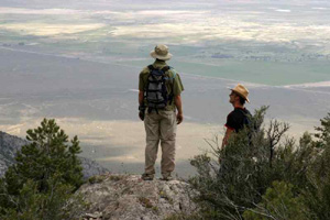
You can only find the Baker-Shoshone Trail on older maps and we thought it would be wonderful to retrace and reopen it. If we were to build the Clock somewhere under the St. Lawrence Mine cabins the revived trail might be a great scenic route down for hikers after experiencing it.
Fortunately the Baker-Shoshone Trail is still marked on GPS maps of the area. Alexander, Danny, Kurt, and I set out to scout the trail downward from the St. Lawrence Mine cabins. We started in the worst of the forest fire burn, the earth still scorched, dead trees everywhere with intact bark on the upwind side. There was no physical trace of the old trail except for animal tracks exactly where the GPS showed the trail used to be. (Are other mammals using GPS too, now?) We sidehill-dodged along for a mile and half, and had a couple great views into Lincoln Canyon. The trail headed over toward the western cliffs, with big views there. From there it went seriously downhill in every respect into Lincoln Canyon. We encountered scratchy bushes, ankle-biting rocks, and a very steep, edgy descent. We finally made it down, but will not do it again. Scratch reviving the Baker-Shoshone Trail, at least its western part.
17 June, Tuesday. Weather station, cliffs epiphany, Young America claim.
Danny Hillis and I had reached a place on Mt. Washington we hadn't sought and weren't prepared for.
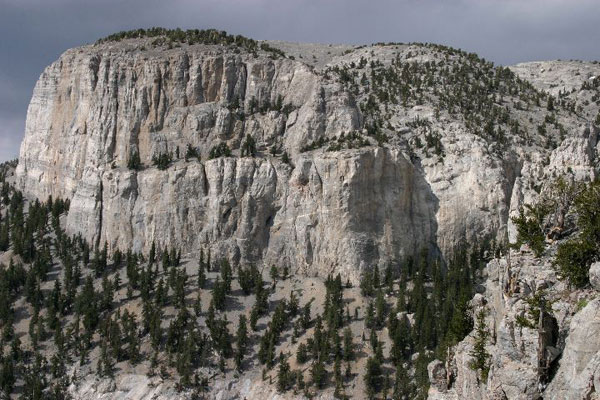
All we had in mind was a short hike up the ridge above the weather station, where Alexander Rose and Kurt Bollacker were toiling once more on fixing it. We'd go up a little ways to get a closer view of the vertical western cliffs of Mt. Washington and the white limestone cirque at the head of Pole Canyon.
But the view riveted us and drew us onward. With every step it became more impressive. The cirque expanded to Cinerama scale, filling 170 degrees with limestone. Spring Valley opened up behind us, with range after range of Nevada coming into view. There began to be bristlecone pines around us. Maybe we'd just go to where the ridge met the white limestone in a sharp ridgetop and get the view from there.
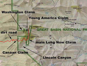
With increasing altitude our IQ went down and affect went up. Soon our dialogue consisted entirely of "This is pretty cool. Should we keep going? Yes." Up the limestone razor ridge, up the angle-of-repose talus slope studded with ancient bristlecones. Hey, just a little further and we might make it to the actual base of the cliffs! It was more than just a little further.
The outlook at the top of the climb would have taken our breath away if we had any breath left to take. The brilliant white cliffs shot 600 feet straight up overhead, seeming to overhang us. We were in a shallow cave, seated, gasping, looking down at what we had ascended and marveling. The elevation was 10,600 feet—we'd just hiked up 1,600 vertical feet. We felt utterly rewarded.
What if this were the approach for visitors to the Clock?
18 June, Wednesday. Great Basin National Park headquarters.
Alexander and I met with Kathy Billings, the new Superintendent of the Park at the headquarters by Baker. We've heard that Kathy Billings has become a popular Superintendent locally and with her staff, which adds even more importance to her friendly support of Long Now and the Clock idea. She immediately took us to an extended meeting with two staff scientists, "bat guy" Ben Roberts and another guy named Tod.
I mentioned that Long Now might one day buy one of the ranches in Spring Valley and want to restore it to natural condition. Tod responded that his advice would be not to just let everything go, because alien invasive plants would take over and dominate for many years. He would keep the water system going and plant a variety of native plants, give them a head start, and then let the whole system go natural. Ben added that it would be helpful to grade away the human-shaped field edges and drainage ditches, bringing back the natural curves and draining the land faster.
Both of them urged leaving the beautiful cottonwood grove, in part because such groves are seen as revealing cultural artifacts. Wherever you see a cottonwood grove in Nevada, settlers once nested there and planted the trees for wind and sun break.
19 June, Thursday. Pole Adit and Lincoln Canyon.

Ben Roberts met with us at the Pole Adit (Long Now's 1.5 mile mine tunnel). He and I explored the first quarter mile or so, cold water gushing through the place from spring snows. Ben was surprised at the extent and complexity of the mine—he thought there must be four levels of adits. He would love to survey it in detail; we said fine. He gave us the design for a bat entrance in the gate. I'm conflicted: I'd rather not have guano in the otherwise delicious water that pours from the mine opening.
While I went to Ely to deal with digital photo storage problems (I was astonished to find a computer shop in town), Alexander headed up Lincoln Canyon with Ben Roberts. They explored the south fork of the canyon, which has running water throughout, including a 15-foot waterfall.
At the Bonanza Adit Ben and Alexander met lady cave expert Krupa Patel and a youthful, hardy group of summer Park staff. In the evening they put up a mist net over the mine opening for bat study, examining 22 specimens of 4 species. Alexander found them adorable, though eager to bite. They can't fly once stationary for a while, so they crawl around on you. You have to put them in a pocket till they're warm enough to get their engine running, then they fly off. The group camped on the mine's spoil pile. Alexander said it was very buggy until the bats came out, then instantly insect free.
20 June, Friday. Lincoln Canyon and the Lincoln Tunnel (aka Bonanza Adit).

All morning Alexander put in hard volunteer work with the Park team in the mine, four hours in the cold, dark, and wet surveying the whole place with measuring tape and compass.
Later Ben Roberts sent us the result of the survey—indeed the adit does reach Long Now property, right under the bottom of Lincoln Canyon. Researching at the Bureau of Mines in Reno, I learned that the Bonanza Adit is often referred to as the Lincoln Tunnel and was part of the St. Lawrence Mine. It was an effort to tunnel into the base of the silver-lead ore body in the St. Lawrence fault, making for much easier excavation and extraction than from the top. But just as the deep penetration of our Pole Adit found, there was no ore at that 8,400 foot level.
21 June, Saturday. Nighthawk Knoll and Zander's Siq.
At present there are no trails anywhere on or around Mt. Washington. Apart from the rare dirt road, you're bushwhacking through terrain that is not kind to sneakers. Wear boots.
I was exploring the low-seeming knoll in front of Pole Canyon, scouting a possible route up for hikers from the valley floor. I was in touch by radio with Alexander, who made a further adjustment to the weather station far above me and then headed up the ridge to the base of the Bristlecone Cliffs, where Danny and I had been on Tuesday.
All too soon for my pride I heard him report, "I'm at the cliffs. I'm heading up along their base north, and there's this hidden notch going up that I think I can get up a ways." I replied with six varieties of "Be careful!!" knowing that Alexander's new rock climbing skills would draw him toward verticalities. Soon I hear: "I'm halfway up! It's like climbing stairs, going up at about 60 degrees. It's a secret passage. It feels like something from Tolkien." And I'm going, "Be careful, be careful, be careful." And then I hear: "I made it to the top! You can see all creation from here!
And so it was that Alexander Rose made the first ascent of the west face of Mount Washington—a solo ascent at that.
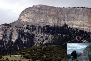
The secret passage up the cliffs has been named Zander's Siq in honor of the famous slot-canyon approach to the lost city of Petra, known as The Siq. Zander's Siq became a reframing component in Danny's thinking about siting the Clock.
At the weather station Alexander discovered that the data line from the rain gauge had been cut yet again—the third time in a year, the second time in four days. "Someone does NOT want us to know about rainfall in Spring Valley," he commented.
22 June, Sunday. Swallow Canyon, Geyser Hot Spring.
On Sunday Alexander and I decided to scratch a long-standing itch and began exploring the canyons to the south of Lincoln Canyon. The closest major one to the south is Swallow Canyon, which features a large cottonwood grove out on the bajada (alluvial plain) in front of it. This turned out to be an idyllic spot with a hidden river springing miraculously from the ground and a fine view to the north of Mt. Washington. It could be a great camping or conference site for Long Now some day.
Next we took on a quest that had been enticing us for days. It was right there on a new map of all the hot springs in Nevada—"Geyser Spring," just twelve miles south of our base camp, right off Highway 93, adjoining a large working ranch called "Geyser Ranch". A wild hot spring nearby! It could be part of a gateway for the Clock from the south!
We bounced for a couple hours on mountain roads but found no spring. We needed a better map. Off to Ely for the night and extravagantly welcome baths at the Hotel Nevada.
23 June, Monday. BLM office, storm.
The Bureau of Land Management is one of the three government agencies we must deal with in any projects on Mt. Washington. Our base camp at Tilford, for example, is on BLM land. Anything we do on the mountain that involves activity underground requires BLM oversight. The bronze and pipe monuments we've been finding at all the corners of our claims are the amazing work of BLM. Until now we'd had no formal interaction with the regional BLM office in Ely, so today we undertook a diplomatic mission with Dave Tilford, who made the introductions.
The regional director wasn't around; we met instead with a deputy who was brand new to her job and then with various functionaries who were entirely welcoming and interested in the Clock project. Alexander got detailed documentation and maps of our 1869 claims for aid in finding exactly where the corners are. The BLM was originally established to sell off government land, and they still do a fair amount of that. We requested to be put on a notification list for any pending sales in our area. We also picked up a topo map showing the route to Geyser Spring.
We battened down for the night, heeding forecasts of four days of thunderstorms. Alexander gratefully stepped into the beautiful, historic sheep camp that Dave Tilford's daughter and family had hauled in on Sunday. I crawled equally gratefully into my yellow Bibler tent, single-walled, four-season, reportedly bomb proof.
Among the first drops of rain were a few snowflakes. A full-on storm rained and blew all night long.
24 June, Tuesday. Forest Service, snow, hot spring.

On this late-June morning we found Mount Washington covered with snow from 8,600 feet up. We had an early appointment with the new regional Forest Service head, Patricia Irwin, and her colleague Barbara to look at our weather station, which was installed with a Forest Service temporary use permit.
The snow got ever dicier as we approached the weather station, three inches among the green aspens, then four inches. Pat's 4-wheeler got stuck; Alexander helped unstick it. The scene was gleeful at the weather station. It felt like Christmas.
Pat seemed completely supportive of Long Now's endeavors on the mountain. We asked about getting a permit to extend the road temporarily up the ridge if we needed it for Clock excavation. "How long is temporary?" they asked. "A couple years," we said. "Anything longer than a season doesn't count as temporary," they said.
Wouldn't a wild hot spring be a nice contrast to all that chilly snow? Clutching the new map, Alexander and I drove south again and closed in on Geyser Spring, eventually striding up a babbling watercourse to the point where it burst fully formed from the ground—cold. Studying the terrain nearby we could see it had clearly always been cold. Some bureaucrat messed up.
25 June, Wednesday. The Long Server Grotto, Ely officials.
This afternoon we were back in Ely to collect Kurt Bollacker and Dave Tilford and checked out our newly granted basement room in the old Bank of America building on the main drag downtown, where our Ely Long Server is meant to be installed. The most visually interesting feature is a robustly metallic walk-in vault; the most important feature is a connection to newly laid fiberoptic cable that spans Nevada (one of only five connections in town).

Mike Keller and Paul Saffo arrived in good spirits, having driven America's Loneliest Highway from California with aplomb. We picked up Kevin Kelly and Ryan Phelan at the airport, and all assembled for dinner at The Jailhouse restaurant along with Ely's mayor, a city council member, and the city attorney, whom we roundly thanked for giving us the bank basement.
The mayor explained his plan to make Ely completely broadband by running fiberoptic to every house. He then got about $300,000 worth of unsolicited advice to scrap that plan and go wireless, delivered by a daunting array of expertise—Saffo, Keller, Kelly, Bollacker, Rose, and Hillis.
I announced that I had to leave early to entertain large-donor Ryan Phelan in my room. I presume those assembled knew we are married.
26 June, Thursday. Bristlecone rings and the clifftop Washington claim.
After rendezvousing at base camp with the four gents from the University of Arizona tree ring lab we all variously ascended the mountain for a day of research. The two youngest bristlecone experts (Chris and Matt) decided to accompany Alexander and Kurt up Zander's Siq, climbing from the ridge above the weather station. We soon learned that the Siq team would be delayed. There was a temperature sensor problem to be fixed with the weather station, and the eventual climb up the Siq took much longer with four than when it was Alexander alone. "You realized," Kurt later said, "that if you didn't put your foot in exactly the right place you could be really, really hurt."
We quickly dispersed into five unplanned groups. I scouted a potential lower route to the south (low) end of the Washington claim by scrambling west across the two still snowy upper branches of Pole Canyon, to see if there could be a direct link from our Young America claim. There was. Its waypoints were added on my GPS to the many GPS specifics being collected by Alexander, toward a comprehensive detailed Long Now map of the mountain.
Eventually Alexander and Kurt headed back down the Siq, Kevin and I watching with trembling knees as they skirted the edge of the abyss on their way into the steep slot.
All the tree ring people went down in my car. I learned that the original discoverer of the extreme age of bristlecones, Edmund Schulman, was pursuing a theory described in his 1954 Science paper as "Longevity Under Adversity in Conifers." Longevity Under Adversity sounds like a potential guideline for Long Now, or at least an occasional reassurance.
27 June, Friday. Board meeting.
I brought in Peter Schwartz from Ely and we commenced the meeting in the white tent provided by Dave Tilford. The sundry current Long Now projects were reported on: the ever-improving Long Bets site; Rosetta's great conference at Stanford and plans for compiling all languages on the website; potential museums for Clock Prototype 2; the elegantly graphic Timeline Software project; the planned stages for Long Server and Digital Preservation work; the arduous Weather Station; Eno's great Bell Studies CD; etc. You would think they were the work of a cast of thousands, but nearly everything was done by the same half-dozen people.
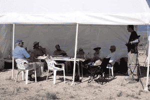
By midafternoon it was hot as we began serious discussion of how the Clock and the Mountain might fit together. Danny suggested we all jump in cars and ascend 4,000 feet to the great lookout cliff edge that gazes north across the Pole Canyon limestone cirque to the Bristlecone Cliffs. It was Peter Schwartz's first time up the mountain. At the lookout it was indeed cooler, and purely spectacular.
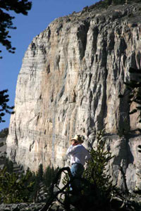
We hunkered down under a bristlecone. Danny explained that he did not yet have a major next stage for the Clock planned out. Mount Washington is looking ever better as the site—pretty much a certainty—but a great deal more research has to be done on it, including some core drilling.

Dave Tilford had quietly attended the whole daylong meeting. As the sun headed toward the horizon a hundred miles to the west, we asked if he had any thoughts to add. "Just one," he said. "When the board of The Long Now Foundation meets here ten years from now, I wonder who will be here. How are you handling the passing on of this institution so it really can go on indefinitely?"
28 June, Saturday. St. Lawrence Mine cliffs, Washington claim again.
Puttering around base camp in the morning felt like vacation for those remaining—Danny, Alexander, Paul, and me. Just as we were feeling ready for more adventure, Jeff Bezos drove in, having flown direct from Seattle. "Whatever you were planning to research on our mountain next," he said, "I'm here to help." So up we went, stopping first to show Jeff the Pole Adit.

Next stop was the St. Lawrence Mine cabins, sturdily made of bristlecone pine logs.
Though these cliffs facing south into Lincoln Canyon have long been one of the two main candidate sites for the Clock, this was the first time we'd examined the area on this trip. Since Paul, Danny, and Jeff are major rock hounds the next hour or so was devoted to whacking with geologist's picks in adits that were open.
With our newly critical eyes, the geology of the area looked less appealing than we thought for a Clock site. Though ornamented with beautiful huge rock-gripping bristlecones, the cliffs tend to spall off in big chunks and the ore body rock where the mine adits go clearly tends to cave in unless aggressively shored up.
It was still early afternoon, so we drove on up to the summit to look for the ever-elusive northern corners of the Washington claim. The group proceeded to the point where the west-facing Bristlecone Cliffs meet the sheer cliffs on the north side of Mt. Washington's peak. Looking down the northern cliff they thought they spotted a BLM monument a hundred feet below us that might be the northwest corner of our claim. Paul Saffo, it turns out, has a past as a technical climber, so he belayed Alexander down the cliff. Indeed the corner monument was there—increasing our respect for the intrepid field crews of the BLM.

Back at Tilford base camp, Jeff was offered the luxurious sheep camp trailer, but he chose to sleep outside on a cot, with brilliant Mars waking him from time to time.
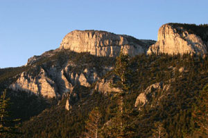
29 June, Sunday. East ridge and the Bigwash canyon.
It was a little like helicopter skiing—all downhill. A little after 7am, Danny drove Alexander, Jeff Bezos, and me to the top of Mt. Washington. The four of us signed in at the jar at the peak and headed northeast down a steepish ridge to the spectacular saddle where our main, two-mile claim terminates on the north, ever vigilant for corner markers.
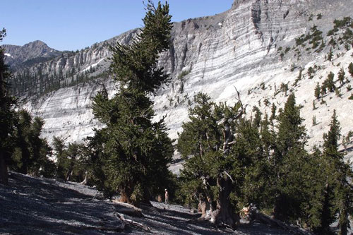
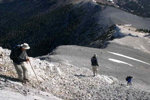
Sure enough, Alexander spied one right on the ridge edge, a northwest corner. That gave us hope to find the northeast corner, supposedly just 600 horizontal feet due east—in very non-horizontal terrain. We fanned out into a beautiful swale filled with exceptionally healthy, ancient bristlecones—the most magical forest we had seen anywhere.
Gradually the going became brushy and steeper, and eventually we dropped off the ridge 2,000 feet down into Bigwash canyon. The amble became more of a forced march. Ten miles from the peak at 4pm we were glad to see Dave and Edith Tilford waiting in a car at to give us a lift to the resort at Hidden Canyon Ranch. Oh god the showers felt good, as did the sweetly provided dinner.
During the long drive around the north end of the Southern Snake Range back to base camp, Jeff gave his considered advice about siting the Clock. "Make it inaccessible. The harder it is to get to, the more it will be valued." And off he flew, due at his office Monday morning.
30 June, Monday. Decamp, Clock thoughts.
Alexander, Danny, and I disassembled the big tent and the whole encampment in Burning Man mode: Leave no trace, and be sure all the right stuff gets back to the right people.
The goal of the expedition was to study Long Mountain and begin to think in detail about how a Clock might fit gracefully into it. What had we learned?
For a couple years there had been two leading contenders for a Clock site: 1) at the St. Lawrence Mine looking south into Lincoln Canyon, 2) in the Bristlecone Cliffs looking west over Spring Valley.
The initial attractions of the St. Lawrence Mine site were the following: It's Long Now property, which makes it easier on permissions. There are extensive existing mine tunnels that might serve it. Maybe we could connect them all for a well-ventilated, circular route under the mountain. A St. Lawrence Clock would be all about Lincoln Canyon. The hike to or from it might be along the bottom of the canyon. The view from the Clock would be into the special remote world of the upper canyon, looking at cliffs from cliffs.
This trip made the St. Lawrence site look somewhat less attractive. The Baker-Shoshone trail would not work as a scenic route down. The geology appeared to be looser than elsewhere on the mountain—therefore less durable over time and somewhat less spectacular. Dazzling at first, Lincoln Canyon palled a little bit with many revisits, compared to other places on the mountain.
When we first saw the mountain back in 1999 the towering Bristlecone Cliffs proposed themselves, almost too obviously. The view from on top, and the trees there, are awesome. Part of the cliffs looks south, so the noon sun could get in to keep the Clock accurate. We don't own the whole potential site, but what isn't under the Washington claim is on Forest Service land, which might be worked with.
This trip added some attractive elements to the Bristlecone Cliffs site. Zander's Siq, most of all, was potentially a hiker's route right up (or down) the fearsome cliffs. The apparent top of the mountain, seen from the valley, is on our land, and that might be conjured with subtly. As we spent more time climbing to the cliffs and hanging out on and around them, they rewarded us more and more. They taught us this: most of the amazingness of the Clock we can borrow from the amazingness of the mountain. The more we highlight and blend in with the most spectacular features of the mountain, the more memorable a Clock visit will be for the time pilgrims. It's a Mountain Clock.
What might be next steps?
Danny and Alexander want to build a series of models exploring the aesthetics of the Clock. At the far end of that might be a working physical model of the Clock inside a model of the mountain. Another approach toward that would be a working tabletop model of the Clock, advancing on what's been learned from the first two large prototypes.
We need to know a great deal more about the mountain, starting with detailed aerial photos so we can make an exact computer model of the relevant parts of Mt. Washington. We need to do core drilling to find out exactly what's in there...water? hidden caves? white dolomite? What we'll be eventually crafting is not a mine but a nuanced sequence of passages and rooms, alert to the exact nature of the rock they're in.
We could build some full-scale working models of Clock parts, such as a solar trigger, or a bimetallic spiral lever and see how much torque it develops from the Mt. Washington day/night cycle through the four wild seasons that so fiercely sculpt those trees.
Many more expeditions to this desert mountain are in store. Here ends the report for this one.
